Overview of Realtor Drone Photography
In the competitive real estate market of Miami, showcasing properties with high-quality visuals has become essential for attracting prospective buyers and accelerating sales. Realtor drone photography offers a dynamic and innovative approach to property marketing, providing stunning aerial perspectives that traditional ground-level images cannot capture. By utilizing unmanned aerial vehicles equipped with advanced cameras, real estate professionals can highlight the unique features of a property, including expansive landscapes, architectural details, and surrounding amenities.
Drone photography enables realtors to present properties from an elevated viewpoint, offering potential buyers a comprehensive understanding of the property's layout and its position within the neighborhood. This perspective is particularly valuable for large estates, waterfront properties, and developments where external features significantly influence buyer decisions. As Miami's real estate landscape is renowned for its luxury homes and vibrant communities, incorporating aerial footage adds a competitive edge to listings and marketing campaigns.
Beyond aesthetic appeal, drone photography streamlines the marketing process by creating engaging virtual tours and promotional videos that can be easily shared across digital platforms. This immersive content helps prospective buyers virtually explore the property from multiple angles, fostering a deeper connection and understanding before scheduling in-person visits. For real estate agents operating in Miami, leveraging professional drone photography services can significantly increase visibility, generate more leads, and ultimately facilitate quicker sales.
As the technology evolves, the quality and versatility of drone footage continue to improve, making it an invaluable asset in the realtor’s toolkit. The ability to capture high-resolution images and cinematic videos from innovative perspectives sets a new standard for property presentation in Miami’s vibrant real estate market.
Legal Regulations and Permits in Miami
For real estate professionals utilizing drone photography in Miami, adherence to established guidelines ensures the safe and compliant operation of UAVs. Navigating the regulatory landscape involves understanding the federal aviation standards, as well as specific requirements imposed by local authorities and property owners. Securing the appropriate permits is a critical step in executing aerial photography projects responsibly and professionally.
At the federal level, all drone operations for commercial purposes must align with regulations outlined by the Federal Aviation Administration (FAA). This encompasses registration of the drone if it exceeds a specific weight threshold and adherence to operational limits such as maximum altitude, line-of-sight requirements, and restricted airspace zones. Maintaining current knowledge of FAA rules helps realtors avoid inadvertent violations that could disrupt marketing efforts or lead to penalties.
Local regulations in Miami may impose additional requirements, especially when operating in designated zones close to airports, private properties, or government facilities. It is advisable to engage with local authorities or consult with licensed drone service providers familiar with Miami’s specific ordinances. In many cases, obtaining prior approval from property owners or neighborhood associations can streamline filming processes and prevent potential disputes.
Furthermore, specific to real estate photography, professional drone operators often possess the necessary certifications and permits, such as Part 107 certification from the FAA, which demonstrates adherence to high operational standards. Ensuring that all drone pilots involved hold valid credentials not only facilitates compliance but also enhances client confidence in the services provided.
Property owners and real estate agents should also be conscious of privacy considerations when planning drone flights. Respecting the privacy of neighboring residents and avoiding intrusive shots is fundamental to maintaining professional integrity and community goodwill. Clear communication with stakeholders before conducting aerial shoots fosters cooperation and helps avoid misunderstandings.
To mitigate legal risks and optimize aerial photography efforts, partnering with experienced drone operators who are well-versed in Miami’s regulatory environment is highly recommended. These professionals typically handle all necessary permitting, coordinate flight plans to minimize disruptions, and ensure compliance with all relevant standards. This approach not only guarantees seamless project execution but also retains the high quality and safety of the footage captured.
By remaining informed about evolving laws, securing necessary permissions, and employing qualified operators, realtors can leverage drone photography effectively within the legal framework. This responsible approach supports the creation of compelling marketing content while upholding the professional reputation of real estate practices in Miami.
High-Quality Equipment and Technology for Realtor Drone Photography
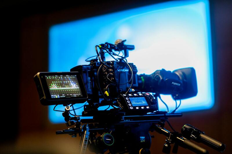
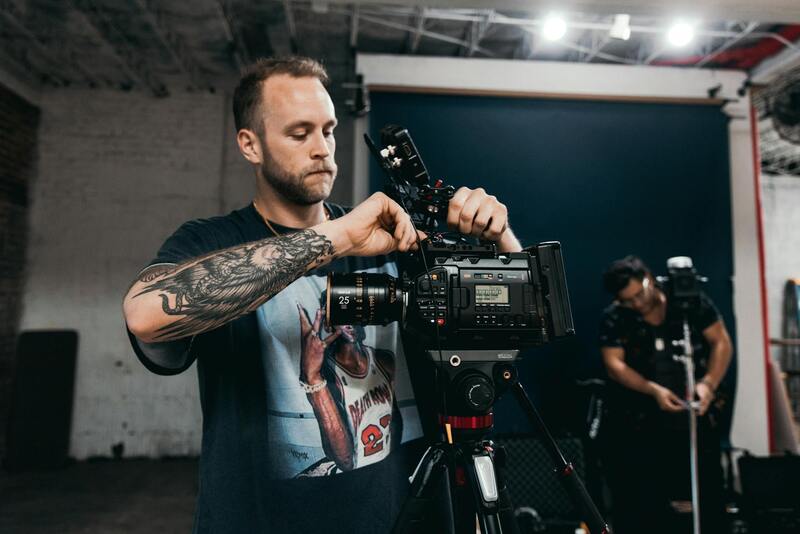
Achieving captivating aerial imagery for real estate marketing hinges on the use of advanced equipment and technology. The selection of drones should be based on stability, camera quality, flight duration, and ease of operation, enabling agents to capture comprehensive views of properties with clarity and professionalism. Modern drones equipped with 4K or higher-resolution cameras are preferred, as they provide crisp, detailed footage that highlights the property's best features. These cameras should also offer adjustable angles and stabilization features to ensure smooth, professional-grade videos and photos.
In addition to the drone itself, supplementary accessories enhance the quality and efficiency of the shoots. Extra batteries extend flight time, allowing for more extensive coverage without interruptions. High-capacity SD cards ensure ample storage for high-resolution footage, while gimbals provide stabilized shots in varying environmental conditions. For optimal results, real estate professionals may also utilize professional-grade lenses and filters to adapt to lighting conditions and achieve desired cinematic effects.
Cutting-edge technology, such as GPS stabilization systems, autonomous flight modes, and obstacle avoidance features, play vital roles in safeguarding equipment and capturing precise imagery. These tools diminish the risks of accidents and improve the consistency of shots, especially critical when capturing complex property layouts or properties located in densely built environments like Miami.
Integrating professional editing software allows for refining raw footage, adjusting color balances, and enhancing details to produce engaging visual content. High-quality images and videos serve as compelling assets for property listings, promotional campaigns, and open house events, providing potential buyers with an immersive experience from anywhere.
Recent Advances and the Future of Drone Equipment in Miami
Technological innovations continue to elevate the standards of realtor drone photography. AI-powered flight paths streamline the shooting process, ensuring precise framing and optimal angles. Thermal imaging cameras are increasingly utilized for specialized applications, such as energy audits or inspection of structural elements. As drone hardware becomes more compact and lightweight, it allows for greater maneuverability and the possibility of capturing shots in previously inaccessible areas.
For Miami's real estate market, staying abreast of these technological developments is essential. Employing the latest equipment not only enhances the aesthetic appeal of listings but also demonstrates a commitment to quality and innovation to clients. Switching to more sophisticated drones or accessories can significantly differentiate a listing in a competitive marketplace.
Understanding the Official Approaches to Drone Operations in Miami
To ensure high-quality realtor drone photography that complies with established standards, professionals employ specific, proven techniques during the planning and execution phases of drone flights. These methods are essential for capturing compelling imagery that accurately represents properties while adhering to best practices for safety, efficiency, and image quality.
Initial flight planning involves selecting optimal weather conditions—calm skies, minimal wind, and good lighting—that are conducive to steady, clear footage. A comprehensive survey of the property is conducted to identify the best angles and vantage points, such as aerial shots from above the roofline, panoramic views of the neighborhood, and close-up captures of key property features like pools, gardens, or unique architectural elements. Using detailed pre-flight maps and GPS waypoints ensures precise navigation, allowing the drone to autonomously follow designated paths to cover the entire property systematically.
Execution of drone flights relies on advanced flight controllers equipped with obstacle avoidance technology, particularly vital in densely built urban areas like Miami. These systems automatically detect and circumvent obstructions such as power lines, tall trees, or neighboring structures, minimizing risks during operation. Pilots typically employ automated flight modes, including waypoints and orbit shots, to achieve consistent, high-quality visuals with minimal distortions or shake. During flight, maintaining a steady altitude—often between 100 to 400 feet—optimizes coverage and detail, enabling potential buyers to engage with a comprehensive view of the property’s layout and surroundings.
Throughout the process, professional operators continuously monitor the drone's status via remote controllers that provide real-time telemetry data, such as battery life, signal strength, and flight speed. This vigilance ensures a safe flight profile, especially in Miami's variable urban landscape. Post-flight, operators review raw footage to confirm that coverage aligns with marketing objectives before proceeding to editing and integration into listings.
By adhering to these methodical practices, real estate professionals can produce aerial visuals that elevate property listings' appeal, offering prospective buyers a vivid, immersive experience. The combination of meticulous planning, precise execution, and advanced technology underpins the success of top-tier realtor drone photography in Miami's bustling real estate market.
Ensuring Proper Methodology for Realtor Drone Photography
When executing realtor drone photography, professionals prioritize adherence to best practices that emphasize safety, image quality, and compliance with regulatory standards. The process begins with comprehensive pre-flight planning, involving careful site assessment to identify any potential obstacles or conditions that might affect drone operation. This planning phase incorporates choosing optimal flight paths, adjusting camera angles, and selecting appropriate flight heights to maximize visual impact while safeguarding surrounding properties and infrastructure.
Prior to takeoff, operators conduct thorough equipment checks, ensuring that all drone components are functional and cameras are correctly calibrated. This step minimizes technical issues that could compromise footage quality or cause safety concerns during flight. Many practitioners utilize advanced flight planning tools and apps that facilitate automated mission sequences, such as waypoint flights or circular orbit captures, allowing for precise, repeatable shot compositions.
During flight, professional pilot oversight is crucial. They maintain constant communication with the drone’s remote control, monitoring telemetry data to sustain a safe and stable flight. Miami's urban environment presents unique challenges, including wind patterns and electromagnetic interference from structures, which require experienced handling. Pilots often operate within predefined altitudes, typically between 100 and 400 feet, to capture expansive, detailed imagery while respecting flight safety zones.
Post-flight, the raw footage undergoes meticulous review. Filmmakers and real estate marketers analyze the visual content to confirm it aligns with the intended marketing strategy. Once validated, editing processes such as color grading, stabilization, and image stitching enhance footage clarity and aesthetic appeal. These professional practices produce compelling visuals that effectively showcase the property’s features, its position within the neighborhood, and its surrounding amenities.
By consistently following structured methodologies—covering pre-flight assessment, technical calibration, precise flight execution, and thorough post-processing—realtors can generate elevating visual content. This approach solidifies the property's market presence and attracts potential buyers by providing a clear, immersive view that elevates the standard of Miami real estate listings.
Legal Regulations and Permits in Miami
In Miami, the deployment of drone technology for realtor purposes is governed by a framework designed to ensure safe and responsible operation. Proper understanding and adherence to these guidelines are essential for any professional engaging in drone photography projects. This includes obtaining the necessary permissions and operating licenses through relevant aviation authorities. Such permits typically encompass flight restrictions, designated no-fly zones, and altitude limitations that are tailored to Miami’s bustling urban environment and proximity to sensitive areas.
Before capturing aerial footage, real estate professionals must review local regulations, which often specify operational parameters such as:
- Restricted flying zones near airports, helipads, and military installations
- Specific altitude limits to prevent interference with manned aircraft
- Time-of-day restrictions to minimize disruptions and maximize lighting conditions
- Notification requirements for authorities when operating within certain areas
Additionally, Miami’s unique urban landscape necessitates meticulous planning to avoid interference from electromagnetic sources and densely populated zones. Working with licensed drone pilots ensures compliance, which not only mitigates risks but also enhances the quality of captured imagery. These professionals are well-versed in navigation techniques that respect flight boundaries while allowing for creative and compelling shots of Miami’s iconic property listings.
Implementing a comprehensive approach that includes pre-flight assessments, acquiring specific permissions, and maintaining communication with local authorities contributes to a seamless operation. Retailing these practices ensures that drone footage can be integrated smoothly into marketing strategies, ultimately elevating property listings without legal complications or operational delays.
Effective Post-Processing Techniques for Realtor Drone Footage in Miami
Post-processing plays a vital role in transforming raw drone footage into compelling visuals that highlight a property's best features and appeal to potential buyers. For real estate professionals operating in Miami, leveraging advanced editing techniques can significantly elevate the quality of listings and foster greater engagement from prospective clients.
Color Correction and Grading
Miami's vibrant urban landscape and diverse architectural styles demand precise color correction to accurately represent properties. Adjusting exposure, contrast, and saturation helps in bringing out the true colors of buildings, landscaping, and surrounding areas. Color grading further enhances the mood and atmosphere of the footage, whether emphasizing the sunny Miami climate or showcasing the sleek modernity of luxury condos.
Stabilization and Image Enhancement
Drone footage captured in dynamic environments may suffer from camera shake or movement artifacts. Advanced stabilization algorithms smooth out footage, resulting in professional-grade videos that maintain viewer focus. Image enhancement techniques, such as sharpening and noise reduction, improve clarity, making details like architectural features and landscaping stand out.
Video Editing and Sequencing
Creating a seamless narrative flow involves strategic editing of drone shots. By carefully sequencing clips, estate agents can craft a virtual tour that guides viewers through the property and its surroundings. Incorporating smooth transitions, zoom-ins, and slow-motion segments adds visual interest and emphasizes key features.
Incorporating Text and Graphics
Overlaying informational text, contact details, or branding elements can reinforce marketing messages. Graphics such as floor plans or area highlights can provide additional context and help viewers better understand the property's layout and location advantages in Miami's competitive market.
Rendering and Export Settings
Optimizing export settings ensures the highest visual quality for online and offline use. Export formats like MP4 with appropriate compression settings maintain clarity while reducing file size for faster web loading. Consider delivering videos in resolutions matching the platform requirements to maximize impact across websites, social media, and virtual tours.
Compliance and Ethical Considerations in Editing
Maintaining transparency and authenticity during post-processing is crucial. Edits should enhance, not distort, the property’s features to provide an honest representation of what buyers can expect. Avoid over-saturation or manipulative techniques that could mislead viewers, ensuring that the visuals adhere to industry standards and uphold trust.
Leveraging Specialized Software for Drone Footage
Popular editing tools—such as Adobe Premiere Pro, Final Cut Pro, or DaVinci Resolve—offer extensive functionalities tailored for professional drone footage. Utilizing plugins and presets designed specifically for aerial videos can streamline workflows and produce visually stunning results tailored to Miami’s dynamic real estate scene. These tools help highlight the unique selling points of properties, from panoramic ocean views to luxurious cityscapes.
Future Trends in Realtor Drone Photography in Miami
As Miami continues to be a hub for luxury real estate and vibrant urban development, the landscape of realtor drone photography is poised for significant evolution. Advancements in drone technology, coupled with innovative imaging techniques, are expected to redefine how properties are showcased to prospective buyers. In the coming years, high-resolution 8K video capabilities will become increasingly accessible, allowing for even more detailed and immersive virtual tours that captivate audiences and facilitate quicker decision-making processes.
Furthermore, the integration of artificial intelligence (AI) and machine learning into drone data processing will enable real estate professionals to automate much of the post-capture editing. AI-driven tools will quickly analyze footage, enhance image clarity, stabilize shaky footage, and even generate virtual staging overlays enhancing the property’s appeal. These developments promise to deliver polished, engaging visual content that stands out in Miami’s highly competitive market.
Another notable trend is the rise of real-time drone data transmission. This technology will permit agents and clients to view live aerial footage during virtual tours or remote property inspections, creating more dynamic and interactive experiences. By enabling instant modifications and on-the-spot feedback, real-time navigation will streamline the sales process, especially for distant or international clientele seeking Miami investments.
As environmental concerns grow, sustainable drone operations emphasizing energy efficiency will become more prevalent. Companies may adopt longer-lasting batteries and quieter propulsion systems, reducing their ecological footprint while maintaining high-quality footage. These eco-friendly practices will align with Miami’s dedication to sustainable urban development and promote responsible marketing methods within the industry.
Lastly, the expansion of 3D mapping and photogrammetry techniques in drone photography will add another layer of valuable detail. Accurate 3D models of properties and surrounding landscapes will enable virtual walkthroughs and detailed neighborhood analyses. This comprehensive approach will empower buyers to explore Miami’s diverse neighborhoods from afar, making realtor drone photography not just a marketing tool but a vital part of the modern, data-driven real estate experience.